Sunday, September 21, 2008

Ride the West - Day Six


Petaluma to San Francisco: Today is my final day of cycling on this 6-day, 404 mile tour of the California coast! What a trip it has been. The day promised to be a beautiful one and the weather was perfect, even as we entered San Francisco. Our start took us through downtown Petaluma, which reminded me a lot of Bellingham, where I went to college. The historic, old town feel of the place is confirmed by several 100-year old buildings and store fronts followed by historic homes as we rode out of town and toward the hills.


The surrounding countryside of Sonoma County has rolling hills, farms, wooded hilltops, and golden valleys. This was the first day of our six that I saw other cyclists. On the coast, I saw a few self supported cyclists, but today we were passed by numerous riders out on a Friday morning ride. We were traveling on popular cycling roads and the local guys and gals flew past us in either direction. One older rider past me exclaiming, "What a morning!" As he passed, I saw his jacket emblazoned with "Sonoma County Cycling Club."


Our route included a few hills, but since our distance was fairly short today, I wasn't worried about taking my time riding up them. The descents, as always, were great. Soaring down recently laid asphalt, I was sweeping in and out of the turns under the warming sun. We turned Nicasio Valley Road which led us toward a series of small towns. In Nicasio, I stopped to photograph a century-old Catholic church. Against the backdrop of the golden hills, it was a postcard-perfect setting.

As we entered Fairfax, we joined a bike route that we would continue on for a few miles. This town was small but charming with an active downtown of shops, cafes, bookstores, and gathering places. A group of local cyclists had already gathered for a rest stop outside of a cafe and were enjoying the sunshine. I don't know who these folks are that get to ride during a Friday mid-morning. But, who am I to talk? I haven't worked in over a week!


Our SAG stop was a few blocks up the road in a parking lot. I was among the first to arrive, so I knew I had to slow down and enjoy the day. We weren't going to be able to get into our hotel rooms any earlier than 3 p.m., so there was no need to rush on this final day. A few past clients of AbB had already dropped by the SAG and donated some freshly baked goodies and local cheeses. Apparently, there are a lot of local riders that have taken part in an America by Bicycle tour. Our current route was at the suggestion of one of those locals. And, boy, was it turning out to be a good one!


Leaving the SAG, I noticed that the towns all ran together. We rode through San Anselmo, followed by Ross, next was Kentfield, then Larkspur. Each of these towns were attractive enough that I could have parked the bike and wandered around them for an hour or so. It seemed each town had it's own bike shop, too. The town of Ross was celebrated it's centennial that weekend and preparations were being made for a big festival.


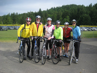
In Larkspur, we began climbing up Chapman Drive, a narrow residential street that wound around and around a 600 ft. hill overlooking the valley below. On the north side, we stopped for a photo, taken by a local resident on a morning walk. We shared with her our adventure of riding that day from Petaluma to San Francisco. She said, "Well, you're almost there! Just over this hill."


As we crested the top, we had our first view of San Francisco, about 10 miles away. We could see the city skyline, Alcatraz, and the Bay Bridge. The Golden Gate bridge was obscured by the hillsides directly south of us. Our descent dropped us down to Mill Valley and Marin City where we joined another bike route. We stopped briefly at Mike's Bikes, a large bike shop right on the trail.


Our route continued southeast along the San Francisco Bay Trail bordered on either side by wetlands. At a brief stop on a low bridge, we admired a blue heron and white crane fishing within 5 ft. of where we stood as the tidewaters went out. A pelican soared overhead and then crashed into the water to fetch his lunch. That made us think of lunch, too. A nice cafe in Sausalito was our destination.


I was riding with Rachel, a 50-ish professor from the University of Bristol in the UK, and my roommate, Boaz, a 44-year old retired military officer from Israel. We selected a waterfront cafe just before downtown Sausalito, and sat down for a small lunch and latte. As we chatted, I realized that if someone had told me a month ago that I would be having lunch in Sausalito with a Brit and and Israeli, I would think they were joking. Then we all agreed it sounding like the start of a good joke... "An American, a Brit, and an Israeli walk into a cafe in Sausalito..." We never got around to writing the punchline.

Downtown Sausalito is a beautiful area. The historic storefronts are busy and active with tourists shopping, eating, and taking photos. The number of cyclists increased dramatically, in part due to those renting bikes to ride across the Golden Gate Bridge and ride further along the trails. We took photos of each other and then pushed up the climb to the visitor center overlooking the Golden Gate Bridge.

Not only was it an international affair, traveling with Rachel and Boaz, but I could hear at least a dozen other languages being spoken all around me. What a change from a few days earlier when we were all alone riding along the California coast.


A couple of turns later, we were on the bridge itself. We were riding on the bay side of the bridge and for most of the time, we were riding at little more than walking speed. Thousands of fellow tourists were walking and biking along the bridge with us. If I had a dollar for each photo taken on the bridge on this day alone, I could probably have paid for this trip a few times over. I took at least 20 photos myself!


We crossed the bridge, stopped at a restroom, then continued on our course into San Francisco along the waterfront. We rode through the Presido, along the Marina, past gorgeous waterfront homes painted in bright colors, and then turned south, uphill, toward Lombard Street where our hotel was located.


Lombard Street... hmmmm. We've got some time, what say we ride east uphill to the Crookedest Street in the World? The three of us voted "Yes", and headed about 10 blocks up Lombard. The climb begins at Larkin Street and as we headed toward Hyde Street, the incline has to be at least 25 percent. For a cyclist, that's almost like climbing up a wall. We leaned forward on our handlebars, dropped into our lowest gear, and huffed "I think I can, I think I can." as we rode upwards.

As I reached the intersection of Lombard and Hyde, I shot my arms up in a victory salute, admired the cable car in front of me letting passengers off, and walked over to the top of the crooked road below. Lombard Street between Hyde and Leavenworth is a series of curvy switchbacks with flower planters on either side and dozens of tourists taking photos from the sidewalks as cars slowly navigate down this famous street.


Boaz and I talked nervous Rachel into joining us on the ride down. We squeezed the brakes tightly and cautiously weaved our way down the brick surfaced street. Tourists walking up the stairs snapped our pictures, probably thinking, "Look at those crazy cyclists! I'll take their picture and wait for them to crash!" But no crashes for us. We reached the bottom, high-fived each other, and then realized we needed to carry our bikes up the stairs to get back to the top. It was like an urban cyclocross route. At the top, we rode back down Lombard heading west to our hotel. We pulled into the hotel, congratulated each other, and celebrated an amazing day of riding.


In many ways I was sad to have to box up my bike and call this ride over. But, a good sign was that I could have continued. As eager as I was to head home and see my wife and kids again, I knew that I still had plenty of energy in me and the desire to see what was on the route ahead. I've learned this week that while I'm by no means the fastest cyclist around, I can push myself day after day to cover more miles, appreciate God's amazing creation around me, and enjoy the company of complete strangers with one thing in common: the desire to ride.

My motto for this week was "More miles, better stories." (A phrase birthed from last summer's ride across Washington state with my good friend, Bryant.) And that will be my goal for the year ahead as I plan to take on the Cross Country Challenge in 2009... More miles, better stories. What a ride!

(If you'd like to read the blog by our route leader, Mike Munk, visit this link and see more photos of the route and meet the other riders.)

Dist: 52.16
Time: 4:43:20
Avg: 11.0
Max: 36.7
Total Ascent: 3667 ft.
Max Elev: 640 ft.
Temp: 51 degrees in Petaluma, 73 degrees in San Francisco
Weather: Clear and sunny in the morning, overcast in the afternoon

-----------

Trip Totals:
Total Distance: 435.82 miles
Total Ascent: 27,298 ft. (for comparison, Mt. Everest is at 29,029 ft.)
Maximum Elevation: 1,848 ft. (Leggett Hill)

Thursday, September 18, 2008

Ride the West - Day Five


Cloverdale to Petaluma: Our ride out of Cloverdale this morning was under clear skies with the promise of plenty of sunshine. Moms were walking their children to school. Folks were headed to work. Work for us? Just 69 miles of riding in some of the best scenery of the week. Our breakfast this morning was 1.2 miles down the road. So we left the hotel, biked a little over a mile, then stopped for pancakes, eggs, bacon, and coffee. We decided at this pace, we'd be stopping to eat over 50 times today!


Following breakfast, we found ourselves in the heart of wine country. Vineyard after vineyard made for amazing scenery. It was like a smorgasbord for the eyes... brilliants greens, lush purples, warm browns and yellows. Every turn was a new scene perfect for a postcard. The roads were a bit bumpy, but the light traffic and the easy rollers made them a blast a to ride upon. I found myself riding for most of the morning with two 70+ year old gentlemen, Tom and Rick. I can only hope that I can ride half as fast as these guys when I'm their age! Rick, in particular, is a hammerhead. We flew along these roads, cresting one small hill and dashing down the other side, over and over again.


Tom's buddies, Bill and Paul, had skipped the restaurant in order to get a head start on the day. But at our fast pace, we caught them. "Hey Bill and Paul," I shouted. "You forgot Tom, so we brought him to ya." Then Rick and I mashed on the pedals and we the first ones to arrive at the one and only SAG stop for the day.


Following the SAG, the terrain and scenery changed. We were riding along the Russian River on a forested road named "Bohemian Highway" through little towns like Guerneville, Monte Rio, Occidental, and Freestone. I would have enjoyed stopping in Occidental and checking it out. The main street had an old town flair with lots of cute shops, bakeries, and "dry goods." 


As we neared Freestone, the terrain changed again. This was cow country. Happy cows come from California. And I saw a lot of the them this afternoon. Smelled them, too. The rolling hills, scrubby trees, and family farms dotted the landscape. In the town of Valley Ford, several of us stopped at a small grocery store for lunch. I grabbed a piece of pecan pie, sat on the step out front, and counted my blessings to be enjoying the sun, riding my bike, and having a great day.


The last 20 miles of the day took us up a couple of climbs, gave us a nice descent past more farms and cows, and dropped us outside of Petaluma. This city of 55,000 suggests that we're no longer out in the boonies of Northern California. We're getting closer to San Francisco, the fourth most populous city in California, and my destination of this ride. Tomorrow is my final day of riding and it will take me right across the Golden Gate Bridge!


(If you'd like to read the blog by our route leader, Mike Munk, visit this link and see more photos of the route and meet the other riders.)

Dist: 71.09
Time: 4:44:18
Avg: 14.9
Max: 34.7
Total Ascent: 3464 ft.
Max Elev: 601 ft.
Temp: 54 degrees in Cloverdale, 84 degrees in Petaluma
Weather: clear and sunny

Wednesday, September 17, 2008

Ride the West - Day Four

Fort Bragg to Cloverdale: As we left the hotel this morning, the gray skies had added a light mist to the weather. Our route out of town was on Highway 1 for about 18 miles. We passed the towns of Mendocino, Little River, and Albion with a few views of the cold Pacific Ocean. As we crossed the long bridge into Albion, the roadway was narrow. Paul, a 70-something rider, took caution and rode a bit further into the roadway than one driver and his girlfriend liked. After shouting at him as they passed, they pulled over to shout further. After Paul rode quietly by, they drove past him again, this time throwing garbage at him. Welcome to Albion, where we throw trash at 70-year-old cyclists... The funniest part is that the time they were slowed down waiting for him on the bridge was eclipsed by the amount of time they took to stop, shout, and throw trash! I guess for them, it's the principle of the matter.


We then stopped for a road construction crew where I noted that the stop sign guy looked an awful lot like a Nathan Adams, a former pastor at Eastside Foursquare Church. I wondered where he had gone. Soon, we were rolling along Hwy. 128 which was much flatter. We were leaving the coast again and entering the Navarro River Redwoods. The temp here was far cooler than our last visit to the Redwoods. It was about 51. But, the scenery made up for the cool weather.


Our first rest stop of the day was at Paul Dimmick campground in the redwoods. Nobody camping there today. I was grateful for the restroom and then restored some of my energy with lots of cookies. The rain had let up by now but we were still in the shadows of the trees. Soon, however, things warmed up a bit. We exited the redwoods and entered wine country.

I was surprised by how vivid the leaves of the grapevines appeared. It was as if they had been painted by a watercolor brush. Clusters of grapes were heavy on the vines. If there hadn't been a fence protecting them, I might have reached over for another snack. The other striking difference was the change in terrain. Rolling hills, eucalyptus trees, and golden grasses surrounded the vineyards. The clouds were lessening and the temp was rising ever so slightly.


One of the points marked out for us on today's route was a fruit and vegetable stand known for amazing apple cider. This was also the halfway point for riders undertaking the full three week trip. Several riders were already there, so I pulled over to join them. The cider was super. I mentioned that I love fall. I love apple cider in the fall. Now, I can say that I love apple cider in the fall while on a six-day bike ride. A glimpse of heaven... 


A bit further was our second SAG stop in Boonville, a tiny but cute town along Hwy. 128. The cafe where we stopped was a good place for a burger and soda as well as a chance to shed the remaining cold weather clothing I had with me. The sun was now out in full force and a bright blue sky was overhead. We climbed for several miles up winding road flanked by orange leaves on the ground. The traffic along here was a little too fast for my comfort, with more logging trucks and passenger cars. 


After climbing for several miles, punctuated by some short descents, I found another highway sign. This time we had made some serious progress toward San Francisco. The distance now: 98 miles! I could ride that in a day. But, I won't have to. We've got two more days ahead of us.

Our final, long descent into Cloverdale was very winding, very rough, and at times heavily travelled. The views were amazing, but too often I had to keep a firm grip on the handlebars and my eyes on the road or in my rear view mirror.


As we rolled into Cloverdale, which has a long tree-lined main street, I spotted another rider to my right. Rachel, a professor from the U.K., had stopped at a mom-and-pop ice cream shop. Another great ending to a great ride. I joined her and soon two other riders did as well. The ice cream was good. It's the little treats at the end of the ride that sometime become the highlight of the day. That and, of course, a shower.

(If you'd like to read the blog by our route leader, Mike Munk, visit this link and see more photos of the route and meet the other riders.)

Dist: 76.81
Time: 5:59:51
Avg: 12.7
Max: 31.7
Total Ascent: 4647 ft.
Max Elev: 1313 ft.
Temp: 51 in Fort Bragg, Low 70s in Cloverdale
Weather: cloudy and mist in Fort Bragg, clear and sunny in Cloverdale

Tuesday, September 16, 2008

Ride the West - Day Three


Garberville to Fort Bragg: At 8:00 a.m. sharp, I pulled out of the Best Western parking lot and began Day Three of the Ride the West. The sky was bright blue and the sun was shining yet it was still cool in the mid 60s. In less than a half mile, we were out of Garberville... and it's colorful, hippie-like population... and onto Hwy. 101. We followed the Eel River south fork for most of the morning, overlooking tree-lined canyons, rocky outcroppings, and slow-moving, clear water. In Piercy / Cooks Valley, we encountered more tourist traps based on redwood tree oddities. I visit the "Grandfather Tree," which was next to the "One Log House"--an actual home built into a single hollow log. A short ways down the road, we passed "Confusion Hill," loaded with oddities, chainsaw carvings, and general weirdness.


Our first SAG stop was across from Standish Hickey Recreation Area at a small store and gift shop. The sun was warm and it was an easy place to linger, but the challenge lay ahead. As soon as we turned off Hwy. 101 and got on Hwy. 1, the Coast Highway, we had a four mile climb up "Leggett Hill," so named for the nearby town of Leggett. As we gained 1800 ft. and counted the miles, sweat poured off my forehead. The trees lining the climb had already discarded many of their leaves and it reminded my how much I love autumn. The smell of the redwoods in the hot sun yesterday, and again for a portion of today, can't be described in photos or words. It's invigorating.

As we crested the hill and rolled along a flat section, and began to prepare for the descent. And descend we did! Over the next 15 miles, we dropped more than 1000 ft. But our elevation wasn't the only thing dropping. So was the temperature. On the climb, the temp was above 70 degrees. At the bottom of the descent, it was 54. I had to stop twice to add another layer of clothing. At the bottom, I hit the gas just to keep warm. The fog and low-lying clouds had returned. Actually, they never left. We were the ones that had returned. We were back to the Pacific coast.


A funny moment was when I saw a highway sign showing the distance to San Francisco. This morning, about 8 miles outside of Garberville, the sign said "San Francisco: 199." Noticeable because it was less than 200 miles now. However, after riding 41 more miles, a second highway sign read: "San Francisco: 199." It was as if we hadn't made any progress at all! I checked to see if I was on a stationary bike.


After another 3 mile climb, which warmed me back up, and a short descent, the Pacific Ocean was in view. The rocks, beach, and rolling surf was beautiful. But Mike, our ride leader, lamented that it wasn't sunny. The ocean, he said, is a brilliant blue when the sun is out.

Our second SAG stop was at a State Park overlooking the ocean. All of us rolled in shaking from the cold. We grabbed some snacks and then decided to try out a cafe about three miles down the road. What we found was a grocery store with a sandwich counter. A woman inside was the sole employee and we found that she lacked not only charm, but also any sense of customer service. At the end of the ride, we all compared notes of our visit to the store and our exchanges with her. Here's a sampling: Craig: "Hi! How are you today?" Lady: "Not good." Mike: "We're not from around here." Lady: "I'm painfully aware." About 7 of us stood inside thinking about ordering a sandwich. Lady: "Whatever you do, there's only one of me. So, plan on waiting for awhile." Us: "Uh, let's go somewhere else." One of our riders actually got a sandwich out of her. When he handed the slip of paper to her with his order, she replied, "I accept your application." Apparently, these small coastal towns don't need as much tourism dollars as we thought.


The remaining 17 miles to Fort Bragg were rollers along the coast through a few more small towns. Logging trucks, work trucks, and speeding passenger cars blasted past us and we plodded along under the increasingly gray sky. As I entered Fort Bragg, I was eager for a hot shower. After finding the hotel shortly after 3:00 p.m., grabbing my luggage, and getting said hot shower, I took a walk and found the highlight of my day... a Starbucks!

Dist: 70.04
Time: 5:44:28
Avg: 12.1
Max: 36.7
Total Ascent: 6309 ft.
Max Elev: 1848 ft.

Monday, September 15, 2008

Ride the West - Day Two


Today... I'm sold! Many of you know that my rationale for riding the America by Bicycle "Ride the West" was to conduct sort of a "shakedown" ride in advance of next summer's Cross Country Challenge (52 days from San Francisco, CA to Portsmouth, NH). I wanted to see what this organization is like, what a ride of this magnitude is like, what to expect, what to plan for. Today's route from Eureka, CA to Garberville, CA sold me. We rode the bulk of our day through the Avenue of the Giants... a scenic bypass parallel to Route 101 that takes you through the most amazing forest I've ever visited: The Redwoods of Northern California.

Our day began under cold and cloudy skies as we departed Eureka. I remembered that it was a Monday as I saw kids on their way to school and school buses passing by as we rode through neighborhoods and past shopping malls. We were on Hwy. 101 for a brief 5 miles when we began following side roads that run along the Eel River. Little towns like Loleta, Ferndale, Rio Dell, and Scotia gave us a good indication of the industry in southern Humboldt County: farming, dairy, and timber.


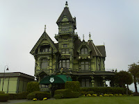
Our first rest stop was in Ferndale which is unique in that the main street through town is replete with Victorian buildings and homes. Ferndale has been dubbed "the best preserved Victorian village in California." It reminds me of Leavenworth, WA... a small, hidden hamlet making a name for itself by theming an entire village.

Leaving Ferndale, we were soon in dairy country. Farm after farm has dairy cows with as many as 100-200 head of cattle. I wonder what cows think of cyclists... They kinda just stare at us. Don't say much. But, I know they're thinking something... Probably something like "Mmmm... salty." (Cuz we really are. Quite salty in fact.)


After riding some country roads, we entered Rio Dell and then it's neighboring Scotia. Scotia has an attractive main street and a short few blocks further, I saw the largest operating sawmill I've ever seen. We returned to Hwy 101 for a few miles and then entered the "Avenue of the Giants." The next 30-plus miles was some of the most amazing scenery I've experienced. Majestic redwood trees towered overhead while sunlight dappled the forest floor and roadway ahead. I took time to drop by each and every tourist stop. I was treated to the "Immortal Tree," followed by the "Eternal Tree House," and then the "Drive Through Tree," which were not to be outdone by the "Chimney Tree." Most of these trees are hollowed out trunks which are possible because the Redwood doesn't have a taproot. It's roots reach down 6 or 8 feet around the perimeter of the tree, leaving the center of the tree able to become hollow over time.


In addition to experiencing beautiful scenery, we also got to experience something new for this ride... HEAT. As we moved inland, away from the coast, the temperature climbed. It was barely 60 degrees when we left Eureka, but it was easily in the mid 80s in the forest and would be 100 degrees when we reached Garberville.

The little town of Miranda was a great place to stop for lunch or a snack for several riders. As I pulled in to the Avenue Cafe, about nine other cyclists were already there. I wasn't up for a big lunch, but I saw something on the menu that hit the spot... a rootbeer float. After enjoying it's creamy goodness, I hit the road for the last 13 miles. These were the hottest miles of the day. And we had one more long climb up to Garberville to finish things off. We climbed and climbed until we finally pulled into the Best Western in Garberville. As I mentioned, the temp was 100 degrees. I was cooked. It was time for a shower and then something cold and refreshing.

Tomorrow, we return to the coast as we ride a "short" day of just 68 miles to Fort Bragg, where it will probably be cooler again. Everyone complained about the cold and fog. Now they're complaining about the heat. I'm just grateful to be riding!

(If you'd like to read the blog by our route leader, Mike Munk, visit this link and see more photos of the route and meet the other riders.)

Time: 6:01:30
Dist: 80.83 miles
Avg: 13.3
Max: 36.7
Total Ascent: 4276 ft.
Max Elev: 533 ft.
Temp: 60 degrees in Eureka, 100 degrees in Garberville
Weather: cold and cloudy in Eureka, clear and sunny inland

Sunday, September 14, 2008

Ride the West - Day One


My first day riding the "Ride the West-Central Leg" met my expectations... and probably exceeded them. We began our day at 6:30 a.m. for breakfast at the hotel followed by some time to gather all our gear and ready for the ride. Luggage was loaded on the van at 8:00 a.m. and I was out of the parking lot six minutes later under a foggy cool morning. The fog stayed with us for most of the day but as we began our 10+ mile climb out of Crescent City and into the Redwood National and State Park, we soon got a pleasant glimpse of sun and blue sky. As we climbed out of the fog, the sun cascaded through the the mist creating inspiring beams of light shining down upon us. The trees were enormous. And, as I was warned by Mom, it's hard to ride while gazing up at the treetops.


The long climb warmed me up and was promptly followed by a fast descent into Klamath where I once again visited Paul Bunyan and Babe the Blue Ox at the Trees of Mystery. The other cyclists were entertained by the talking Paul Bunyan and how he could turn his head and wave his hand.


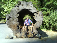
After Klamath, we rode through another portion of the Redwoods along Newton B. Drury Scenic Parkway. The tree trunks were huge and seemed to just get bigger. I found myself quietly saying, "Wow... Wow!... Wow!!!" as I passed larger and larger trees. As I caught up with two other riders, Craig and Dan, who were slowly riding by admiring the Redwoods, we passed a tree with a hollow trunk and climbed inside for a quick photo. Shortly after, we passed a sign reading "BIG TREE" pointing to the left. Good thing there was a sign... cuz you really wouldn't notice the BIG TREE without it! We thought that was pretty funny. But then realized that was the name of the park where our first SAG stop was located. (A "SAG Stop" is for "Support And Gear" and is where our rest stops are with food, water, facilities, and a chance to get off the bike.


Shortly after leaving the SAG stop, we passed through a large viewing area with a herd of Roosevelt Elk. While Roosevelt Elk are not uncommon in Oregon and Washington, only a small number of these animals are in California and principally in northern Humboldt County where we were riding today.


The next 20 miles took us through the small town of Orick and rural areas along Hwy 101 with occasional views of the ocean. We took a parallel road as we neared our next SAG stop that featured lots of bed and breakfasts and small motels tucked along the ocean in the town of Trinidad. We were a long ways from the Caribbean... and the weather was anything but Caribbean-like, but our stop in Trinidad did feature some savory Mexican food at the Chevron before we headed out along Scenic Drive and enjoyed even better views of the ocean including haystock rocks and beaches dotted with rock formations.

Our next interesting portion of the route was along the Hammond Trail bike path that fronted the ocean beach. At one point, I stopped to inspect a large group of what looked like big dead fish about 300 ft. away on the banks of a small inlet. On further inspection, it was about three dozen harbor seals lounging on the sand.

After the bike path, we hit some farmland and dairy farms along some bumpy farming roads. We entered Arcata, which struck me as a small community with mostly young hippy kids wearing dreadlocks and riding skateboards. We then followed the perimeter of Arcata Bay as we rode into Eureka, CA.
Our route took us through Old Town past stately Victorian homes and businesses in historic buildings. We arrived at our hotel, Best Western, just after 4 p.m. Route Rap (where we discuss tomorrow's route) and Dinner (at a nearby barbecue diner) filled out our early evening. Time to rest and get ready for another nearly 80-mile ride tomorrow to Garberville!

If you'd like to read the blog by our route leader, Mike Munk, visit this link and see more photos of the route and meet the other riders.

Dist: 84.89 mi.
Time: 6:29:09
Avg.: 13.0
Max: 33.8
Total Ascent: 4935 ft.
Max Elev: 1181 ft.
Temp: 60 degrees
Weather: foggy, cloudy, some sunbreaks

Saturday, September 13, 2008

Ride the West - (Central) - Day 0


Well, the ride is about to begin. Susie, Kyle, Bethany, and I drove from Bothell to Olympia on Thursday and continued on yesterday to Crescent City, CA. Today we explored the Trees of Mystery in the Redwood forest, visited a lighthouse on the coast, and finally said farewell at 3:00 p.m. I attended our Orientation meeting with Mike, Barbara, and Karen--the tour leaders--along with three guys from Mexico who almost didn't make it here in time due to their flight coming through Houston and having to be re-routed because of hurricane Ike.


Our orientation was pretty thorough. They covered safety and traffic issues, explained tomorrow's route, talked about what they expect of the riders and what we can expect of them. It looks like I'll be the youngest rider in the group. The riders are all ages, but mostly 40-70 and from all over the country. And with the three guys from Mexico and my roommate--he's from Israel--it's an international group as well.

Tomorrow's route will take us through the Redwood forests along Hwy. 101 through Klamath, Orick, Trinidad, Arcata, around Humboldt Bay and into Eureka. The distance is 82 miles. Hopefully, the fog will lift and we can begin the route from the hotel. But if visibility is poor, we'll be driven the first 15-20 miles over the first mountain where the fog isn't so dense.

Since today is a rest day for the other riders, there's no planned dinner. I'll see if my roommate is awake and then probably walk around Crescent City to find some dinner and get things ready for an early breakfast (6:30 am) and a first day of riding tomorrow!

If you'd like to read the blog by our route leader, Mike Munk, visit this link and see more photos of the route and meet the other riders.

Wednesday, August 20, 2008

RSVP 2008 - Hot, Hotter, Hottest


The "Ride from Seattle to Vancouver, BC and Party" 2008 began for me in Bothell where I met two other riders, Jay and Johnny. We met up with Gary in Maltby and added two more riders to our group in Lake Stevens. The route on the first day, Friday, from Seattle to Bellingham, is a beautiful ride paralleling I-5 along back country roads, Highway 9, and Chuckanut Drive and goes through Lake Stevens, Arlington, Bryant, Mount Vernon, Burlington, and Bow/Edison. Hands down, the best part of Day One is along Chuckanut Drive overlooking Bellingham Bay. The weather was very warm, easily in the mid 80s, and we worked to stay hydrated. Fortunately the breezes kept us cool. Unfortunately, some of those breezes were headwinds. Especially in Skagit County before reaching Chuckanut Drive. But we had strong riders with us that pulled us nicely through the flat farmlands as we rode in a tight paceline.

Upon reaching Bellingham, most of our group stopped at either a hotel or at Western Washington University to spend the night. I, however, had another 20 miles to ride to reach Lynden where my family was camping at a KOA campground. The benefit to me, I got to sleep in on Saturday and only had to ride two miles before breakfast!

We started Saturday in Lynden for a sit-down breakfast at Dutch Mothers Restaurant and an all-you-can-eat buffet with about 100 other riders. Following breakfast, we continued north through the Lynden farmlands until reaching the Aldergrove US/Canada border crossing. The day was heating up and we spent most of Saturday riding in 90-100 degree heat. One memorable stop was at mile 144 where a public park featured a water spray area for toddlers and preschoolers. It was humorous to see a bunch of old cyclists standing amidst the little tykes and getting thoroughly soaked--fully dressed. But it kept them cool!

Our final miles into Vancouver were from the east riding along residential streets and dropping into Chinatown and then through Gastown and along the waterfront of Downtown Vancouver. The day was beautiful, if a bit hot. The scenery of the day was stunning and this continues to be one of my favorite rides.

Check out more of the photos here.

Thursday, July 31, 2008

RAMROD 2008 - Pain is Guaranteed, Suffering is Optional


The good news is I FINISHED! The bad news… this is hands-down the toughest ride I’ve ever endured. The weather was perfect. While it was raining at home in Bothell, we had blue skies and sunshine in the low 80s. The only bit of rain we got was in the last half hour of the ride. The mountain was sporting a little cloud hat, but the views were still outstanding. The descents were amazing, soaring at 35 miles per hour down 9 miles of downhill. The climbs however were another story. I knew it was going to be a long, hard day.

Kristin, Bob D. and I left Enumclaw at 5:55 a.m. It was 43 degrees and most of the riders around me weren't dressed for it. But by Eatonville, things warmed up and soon we were at 59 miles and just outside Mt. Rainier National Park. I said farewell to Kristin and Bob at mile 59 and never saw them again until the finish line. The first climb up to Paradise is about 15 miles long. I had to take it two miles at a time, resting and then continuing. I was ecstatic to finally arrive at the top. But two more climbs were ahead. The second climb up Backbone Ridge is only 3 miles so that was mentally easier to take on. I stopped for a victory photo at the top and then enjoyed another amazing descent. The last climb of the day to Cayuse Pass is 9 miles and the steepest. It was also the hottest during this climb. I’ve never been so relieved to see the top of a mountain pass as when I summitted Cayuse!

One final descent and then a long 35 miles of rollers back into Enumclaw. I finished at 8:10 p.m. So for the record, that’s about 12+ hours on the bike and 154 miles. But, I wasn't last. Of the 800 riders that began this ride... four finished after me. But finishing fast wasn't my goal... just finishing.

Check out more photos here.

Wednesday, June 25, 2008

Having a Blast on Mount St. Helen's


Saturday, June 21—Tour de Blast This was going to be a great weekend to ride... Eight of us gathered at Eastside Church to carpool down to Castle Rock, WA. We were headed for an 84 mile ride with 7500 ft. of climbing up Mount St. Helen's. As we gathered, a few of us realized that we've never seen some of the other riders in street clothes. Usually, these people are wearing bike gear, helmets, and sunglasses... With "regular clothes", make-up, and hair in place, a few are almost unrecognizeable! It reminds me of the Reunion Show on CBS' Survivor reality TV series. After weeks of seeing those competitors living on an island, you can barely recognize them when they appear clean and well-groomed. You get the point...

Our Friday evening ride was long and tedious for the guys who drove I-5. The "gals" (me and three women... just one of the girls, huh?), took I-167 and experienced smooth sailing. It was a precursor for Saturday's ride. The girls and myself would summit easily while only two of the four men would. But, I'm getting ahead of myself.

A filling dinner of pizza or spaghetti at Dirty Dave's in Olympia gave us the fuel we needed for the ride ahead and then we finished the drive southward. Our night's accommodations in Castle Rock was the Mount St. Helen's Motel. Three double beds and plenty of floor space for the five guys. So after unpacking, readying our bikes for the day ahead, and laying out our gear, we hit the hay. Only Rick decided to stand guard into the wee hours of the morning since he couldn't get to sleep.

Breakfast at the restaurant next door was good, filling, and probably unhealthy, but plenty of calories to burn throughout the day. The weather was looking to be far better than what we anticipated. We had brought enough clothing for anything from 30 degrees to 80 degrees...torrential downpours, snow, or whatever else came our way. But temps hovered around 77F with an overcast sky. Perfect riding weather. We were blessed.


The first miles turned over quickly for me with good conversation, great scenery, and a decent rest stop around Mile 18. The next stage was about nine miles of gentle climbing up to Elk Rock at 3800 ft. for our second rest stop.
I felt great and kept chugging along. Rick and Mike were long gone as was Kristin. But Warren, Brenda, Jim, Chris and I arrived at Elk Rock fairly close together.


After a fairly good rest, food, and photos, we raced downward on the long descent to Clearwater Lake. But, what goes down, must go up... at least on this ride. We had another climb of six miles to Johnston Ridge Observatory, at 4800 ft. elevation. Warren was done at Elk Rock. Jim turned around shortly after Clearwater Lake, and it was just me and the three ladies making the climb up to Johnston Ridge. (Mike and Rick were so far ahead of us, we figured they were probably done by now!)


I was surprised to see snow on the climb. In past years, the snow level is far above our highest elevation. But with the late Spring (was there one?), the snow was still in place and nearly 12 feet deep along the side of the parking lot at Johnston Ridge.

Our return flight down from the summit back to Clearwater Lake was fast and furious. Soon, we were back to climbing on our return to Elk Rock. The day was getting late, but I was enjoying the ride, felt great, and going at my own pace. I reconnected at Elk Rock with Kristin and Jim, and soon Chris arrived. Chris waited for Brenda and the other three of us started the amazing nine mile descent from Elk Rock. But our ride was interrupted by a disturbing scene. Another rider had crashed about a half hour earlier. EMS was on the scene. We heard he was unconscious, obviously bleeding from the head, and had to be airlifted by helicopter to Portland. The next day we learned that he was going to be okay.


The scene on the side of the road reaffirmed that our avocation is not without risk. Whether descending Mount St. Helen's at 42 miles per hour or just crossing the street in my neighborhood, there's risk. Life is fleeting. And I realize this life is not my own. It belongs to the Lord. I'm thankful... so very thankful... for every day I am given... to live, to breathe, to grow... and, of course, to ride.