
We liked to call it the Skagit "Headwind" Classic. But this year, I started accentuating the positive and this ride is now known as "The Cookie Ride." It's the Skagit Spring Classic with routes of 25, 45, 62, and 100 miles. I had never ridden the Century (100-mile) route and a few of us were ready to tackle it. I usually hit my first century ride on Memorial Day weekend, but I was willing to give it a go a few weeks early this year.

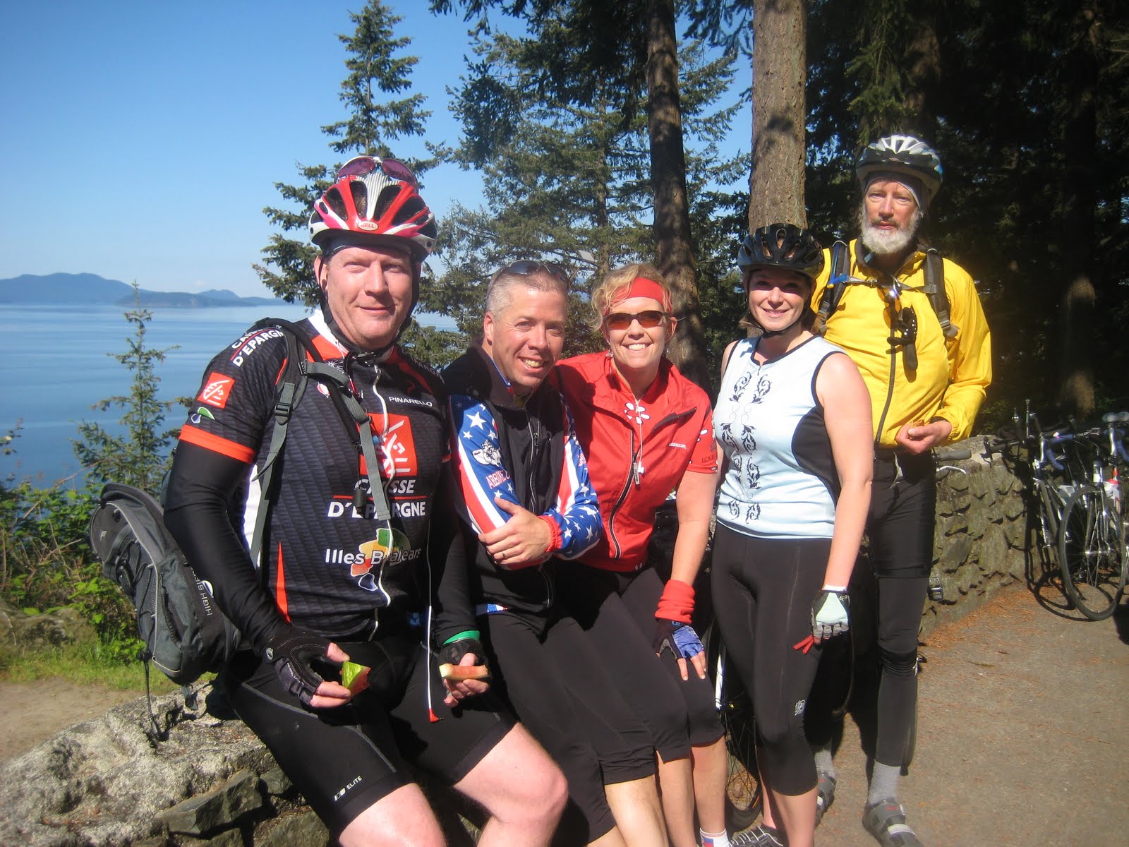
The day was looking to be a beauty. The skies were azure blue with a few white, puffy clouds. The weather was slightly cool but would warm up nicely without being too hot at all. Our group of seven—myself, Kristin, Tenille, Warren, Jim, Brenda, and Dale—arrived in two carpools, checked in, geared up, and hit the road. The winds near the Skagit Regional Airport were strong but our spirits were high. I glanced down at my cyclometer and noticed Kristin and I were going at a good clip. This was gonna be a good day!
We worked our way over the first 12 miles or so in the Skagit flats until we reached the base of Chuckanut Drive. Chuckanut is one of the most scenic drives in Western Washington, in my opinion. It flanks Bellingham Bay overlooks Lummi Island to the west with tall conifers along the roadway and steep rocky cliffs. We sailed uphill and rocketed downhill until we reached the first rest stop. Ah! Cookies! Here's an excerpt from SSC's website: "The Skagit Spring Classic is often referred to as the cookie ride, and for good reason. We bake thousands of cookies. Cookies of all types, Oatmeal raisin, chocolate chip, butterscotch chip, brownies, snicker doodles; the list goes on and on. It is our intent for you to leave our ride having consumed more calories than you burned." My friend, Rob, had asked me what my MPC (Miles per Cookie) was. By the end of this ride, I think I calculated it to be about 8.
After gorging on a few too many homemade cookies, taking a group photo overlooking Bellingham Bay, and refilling the water bottles, we remounted our bikes and dropped into Whatcom County and began turning east. Our route now took us along Lake Samish paralleling Interstate 5. The scenery was still amazing with crystalline blue waters and verdant green mountains. We made quick work of the miles and eventually hit our second rest stop at mile 38 at Donovan State Park.
Tenille describes what happened next: "Donovan was a tad crowded, and had a line for the restrooms that incontinently covered up the pavement markings saying "century riders THIS WAY" with an arrow pointing towards a small incline. That small mix up would cost us an extra six miles- an expensive six miles, too- being that we climbed the steepest hill before realizing our mistake." We turned out of the state park and had already climbed Bow Hill Road before we realized our mistake.

But before I turn you around, let me tell you about Bow Hill Road, which is probably the hardest hill of the ride and the home of Satan. That's right. The devil lives on this hill. As we climbed Bow Hill, a figure dressed in red and black carrying a... pitchfork? Yep, that's a pitchfork, was standing in the middle of the road, shouting at the riders and poking them with her implement of torture. Did I say "her"? Yes, I did. When I got up to Satan and could hear his voice, I realized it was a woman dressed up in this devilish garb. She was encouraging the riders, playfully whacking them on the back with her trident, and keeping them moving uphill. A few miles later, we were talking about this devil and Tenille said, "Y'know, she told me I was doing a good job!" I replied, "Tenille, if you're getting your 'attaboys' from Satan, you REALLY need to spend more time with Jesus!"

Warren and I both decided the proper response was to quote Jesus in Matthew 16:23, "Get behind me, Satan!" and we added, "And PUSH!"
After realizing our map-fail, we returned to Donovan State Park which added an additional six miles and found our correct route for the 100-mile riders. This section of the route was all new to me and I loved it. We passed by Cain Lake, Reed Lake, and then the gorgeous Lake Whatcom. Somewhere on the shore of this lake in 1990, I was baptized during college. Special memories for me. A park that we passed had a reader board sign that read, "Slow Down, Breathe Deep, Relax, Smile and Enjoy Each Day." A fitting reminder for a day like today. I had only one critique: "Slow Down, Breathe Deep..." The sign was located right next to a honeybucket portable toilet. Not a place I want to slow down and breathe deep.
As we turned south, we got on Highway 9 and enjoyed the smooth road. So much of what we had been riding on all day is known as "chip seal." It's a layer of asphalt or tar with a layer of gravel with a layer of tar and another layer of gravel. It's a cheap way to build a road and very common in rural communities. For cyclists, it's the bane of our existence. It makes for a jarring cycling experience. The only upside, as Kristin noted, is your triceps get a good workout.

Our third rest stop was now in view. I could tell we were at the back of the bus since the rest stop was sparsely populated this late in the afternoon. No problem for us. We had no appointments to make. Just roads to ride. The best part of this rest stop was when one of the volunteers pulled out a tupperware container and remarked, "Well, we always save the best stuff for last." His treasure he was sharing with us: Nanaimo Bars. This Canadian bar cookie is divine. It's chocolatey, rich, and I could have eaten four of them. I stopped at one. I still had some miles ahead of me. But, that Nanaimo bar gave me the fuel I needed for the remaining 30+ miles.
We now looped towards Sedro-Woolley and hit another big hill along Gripp Road. The climbing was steep, but the hill was short. I said to Kristin, "That hill has nothing on Cayuse Pass, huh?" Cayuse Pass is in Mount Rainier National Park and is one of the longest, hardest climbs I've done. Once you've got "impossible" under your belt, "hard" doesn't really register anymore.
At about mile 80 or so, I decided I needed some distraction to get through these remaining miles. iPod to the rescue. I turned on my iPhone speakers and played some of the same tunes that got me across the U.S. last summer on my cross-country tour. This was my first century since completing my cross-country challenge and a lot of memories were coming back. At this point specifically, memories of a tired, sore butt. Legs, feet, and ankles were all doing fine. But my backside was voicing it's disapproval.
Now we were back at Donovan State Park for the second time and ready to take the Bow Hill route that we errantly took earlier in the day. It seems Satan had gone home for the day. But the hill hadn't gotten any easier. Now we just had roughly a dozen or so miles ahead of us. We navigated the flat roads west of Burlington and along Bayview and Edison. I was feeling the effects of six and half hours on the bike and ready to reach our finish line and feast on the spaghetti dinner promised to us. My only worry was that the sign at registration said the dinner closed at 4:30 p.m. We were fast approaching that time. I called Warren and got word back that they'd be serving spaghetti until 5:00 p.m. We'd make it. But barely.

The remaining miles clicked by. I was riding with Tenille and I could tell she was nearly cooked, but we battled through those final turns and then reached the school where our fellow riders and our beloved spaghetti were waiting. My first century of 2010 was in the bag. And with our bonus miles, we had extended this ride to a rowdy 109 miles. I was done, but grateful for a beautiful day, the health to ride through it all, and great friends to experience it all with.
Oh, and a whole lot of cookies to eat along the way!
Riders: Bob H., Kristin, Warren, Jim, Tenille, Brenda, Dale
Distance: 109.02
Time: 6:58:51
Avg: 15.5
Max: 38.0
More photos are here.

No comments:
Post a Comment